Showing posts with label moon. Show all posts

Friday, September 10, 2010

China to launch next lunar space mission

China is on track to launch its second lunar satellite by year's end, as the country pursues its plans for a manned mission to the moon by 2020.
The Chang'e-2 mission "is currently undergoing pre-launch testing and preparations -- the plan is to carry out a trial flight mission by the end of the year," the paper quoted Wu as saying.
Space programme officials had said previously that the mission would be launched in October, but no precise date has been given.
The lunar probe will test soft-landing and other technologies in preparation for the launch of the Chang'e-3, which is slated for launch in 2013 and aims to be China's first unmanned landing on the moon, the report said.
The Chang'e programme, named after a mythical Chinese goddess who flew to the moon, is seen as an effort to put China's space exploration programme on a par with those of the United States and Russia.
China launched Chang'e-1, which orbited the moon and took high-resolution pictures of the lunar surface, in October 2007 as part of China's ambitious three-stage moon mission.
China's lunar programme hopes to bring a moon rock sample back to earth in 2017, with a manned mission foreseen in around 2020, according to state media.
Chinese scientists ultimately plan to build an observatory on the surface of the moon, previous reports said.
China became the world's third nation to put a man in space independently -- after the United States and Russia -- when Yang Liwei piloted the one-man Shenzhou-5 space mission in 2003.
In September 2008, the Shenzhou-7, piloted by three astronauts, carried out China's first space walk.
The Americans have achieved the only manned lunar missions, making six trips from 1969 to 1972.
Beijing has other significant Asian competitors to reckon with as it vies to become the second nation to put a man on the moon.
India landed a lunar probe in 2008, and a top official said in January it was targeting a manned space mission in 2016. Japan, meanwhile, launched its first lunar satellite in June last year.

Monday, June 22, 2009

NASA Scientists Bring Light to Moon's Permanently Dark Craters


A new lunar topography map with the highest resolution of the moon's rugged south polar region provides new information on some of our natural satellite's darkest inhabitants – permanently shadowed craters. The map was created by scientists at NASA's Jet Propulsion Laboratory, Pasadena, Calif., who collected the data using the Deep Space Network's Goldstone Solar System Radar located in California's Mojave Desert.

read on

Wednesday, November 26, 2008

LASER Instrument on Chandrayaan-1 Successfully Turned ON

Lunar Laser Ranging Instrument (LLRI), one of the 11 scientific instruments (payloads) carried by Chandrayaan-1 spacecraft, has successfully been turned ON . The instrument was switched ON when the spacecraft was passing over western part of the moon’s visible hemisphere. Preliminary assessment of the data from LLRI by ISRO scientists indicates that the instrument’s performance is normal. LLRI sends pulses of infrared laser light towards a strip of lunar surface and detects the reflected portion of that light. With this, the instrument can very accurately measure the height of moon’s surface features. LLRI will be continuously kept ON and takes 10 measurements per second on both day and night sides of the moon. It provides topographical details of both polar and equatorial regions of the moon. Detailed analysis of the data sent by LLRI helps in understanding the internal structure of the moon as well as the way that celestial body evolved.

Friday, November 7, 2008

Chandrayaan-1: first images
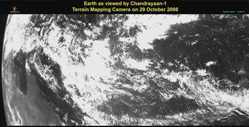

It was another proud moment for the country. Prime Minister Manmohan Singh was shown the first pictures that were taken by Chandrayaan-1 through the Terrain Mapping Camera on Friday.The TMC was operated in October through a series of commands, which were issued from the Spacecraft Control Centre of the Indian Space Research Organisation Telemetry, Tracking and Command Network in Bengaluru.The first images, which were received by the Indian Deep Space Network at Byalalu was later processed by the Indian Space Science Data Centre. The first images were taken at 8 am from a height of 9,000 km.The Terrain Mapping camera (TMC) on board Chandrayaan-1 spacecraft was successfully operated on October 29, 2008 through a series of commands issued from the Spacecraft Control Centre of ISRO Telemetry, Tracking and Command Network (ISTRAC) at Bangalore. 


Analysis of the first imagery received by the Indian Deep Space Network (IDSN) at Byalalu and later processed by Indian Space Science Data Centre (ISSDC) confirms excellent performance of the camera.The first imagery (image 1) taken at 8:00 am IST from a height of 9,000 km shows the Northern coast of Australia while the other (image 2) taken at 12:30 pm from a height of 70,000 km shows Australia’s Southern Coast. 

TMC is one of the eleven scientific instruments (payloads) of Chandrayaan-1. The camera can take black and white pictures of an object by recording the visible light reflected from it. The instrument has a resolution of about 5 metres.

Links: ISRO

Rediff News

Wednesday, October 22, 2008

India on the moon: Chandrayaan-1 successful


Chandrayaan-1, India’s maiden moon spacecraft, was put into Transfer Orbit around the earth by the Polar Launch Vehicle PSLV-C11 after it blasted off from the Satish Dhawan Space Centre.

The 1,380 kg Chandrayaan-1, carrying 11 payloads, was released into a Transfer Orbit 18.2 minutes after the PSLV-C11 blasted off.

full post